
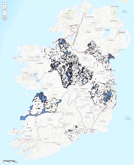
A recent update to the Map of Irish Wetlands has just been published which allows the user to display and query the extent of wetlands in selected counties where targeted wetland surveys have been undertaken. In addition, a 'Wetland Indicating Sediments' layer based on the Quaternary Geology Map of Ireland has been added. The sediments within the layer indicate the presence of wetland conditions (alluvium, lacustrine, blanket peat, raised peat, cutover peat, water, lake marl, coastal marsh, estuarine silt and clays) were extracted to create this standalone dataset. This dataset is very useful in identifying areas where wetlands are likely to exist. Of course drainage and other land-uses may have caused the loss of wetland conditions at many of these sites. The layer suggests that 24% of the Republic of Ireland once supported wetlands. However we have no information on the current extent except for those few counties that have undertaken detailed surveys in recent years. This year, partial wetland surveys have been commissioned by both Westmeath and Longford County Councils with support of the Heritage Council.
This project was developed jointly on a voluntary basis by the Dr Peter Foss (Foss Environmental Consulting) and Dr Patrick Crushell (Wetland Surveys Ireland) and is the only centralised map of all wetlands that occur in Ireland.
The main aim of the Map of Irish Wetlands project is to provide the user with information relating to wetland sites across Ireland. The MIW displays information on over 12,800 Irish wetlands.
As Dr. Crushell explains “We hope the map will prove useful to a range of professionals and general public who are interested in identifying the wetland resource in a given area. In the context of the climate and biodiversity crisis the value of wetlands is becoming increasingly apparent and the extent of this resource is critical in future planning and policy development to address these issues.”
The map can be viewed at either of the following websites: www.WetlandSurveysIreland.com or www.FossEnvironmentalConsulting.com
or
www.bit.ly/MapofIrishWetlands
We are constantly updating photographs of the Irish wetlands. You can submit your photos of your favorite wetland via our app: www.bit.ly/WetlandSnapShot
#MapofIrishWetlands